Understanding Earth’s Ecology from Above
If you picture ecological data collection for the National Ecological Observatory Network (NEON) project, you probably think of a tower at a terrestrial site or maybe even sensors at an aquatic site. But, not all NEON data are collected from the ground.
The NEON Airborne Observation Platform (AOP) is an array of instruments installed into a light aircraft to collect high resolution remote sensing data. Airborne sensor operators in the aircraft use these sensors to collect low-altitude data at much higher resolution than a satellite and from broader areas than a handheld instrument could capture.

Filling a critical hole in ecological data, standardized airborne data collection over the NEON field sites will allow scientists to monitor changes in vegetation patterns and canopy chemistry on a continental scale over an extended time period. The data could provide new insights into how invasive species are spreading and how changes in land use impact forest health. It is also essential to helping researchers compare satellite-derived remote sensing data to ground-collected data.
The NEON project, managed by Battelle for the National Science Foundation, has three AOPs that are used to capture remote sensing data over NEON field sites and collect research-specific flight campaign data requested by the community. Flying 1,000 meters above ground level at 100 knots, the Twin Otter aircraft collect data using an imaging spectrometer, full waveform and discrete return lidar instruments, and a high-resolution digital camera.
A range of physical, biological and biochemical measurements are taken, including topography, canopy chemistry and vegetation structure. Information is available as both individual flight lines or mosaics that combine data from multiple passes over an area. The robust collection of aerial data, synchronized with data collected though tower sensors, soil sensors and observational field sampling on the ground at each site, is freely available on the NEON data portal.
The NEON flight season typically runs from March to October each year. Remote sensing data are collected over aquatic and terrestrial field sites during peak greeness for each site. While preliminary data collection started in 2013, the standard schedule for full operations of the AOP began in 2018. Under the current plan, data are collected from field sites in the continental U.S. and Alaska three years out of every five, and in Puerto Rico and Hawaii every five years. The data are processed after each survey and made available via the NEON data portal. View the 2021 flight schedule here
The data are already being used by scientists for many different projects. Examples include a study by Lawrence Berkley National Laboratory using plant community distributions and canopy biochemistry to understand watershed systems, a University of Wisconsin project building a library of vegetation types that links physical and biochemical traits to spectral data, and a Smithsonian Environmental Research Center project studying tree growth and the exchange of carbon, radiation and moisture between forests and the atmosphere.
Interested in using NEON data for your research?
As Battelle looks to the future of operating NEON, planes aren’t the only vehicle for collecting data from above the ground. The low cost and versatility of drones could help the NEON project expand its airborne remote sensing capacities.
While drones currently lack the payload capacity for the sophisticated sensors required to wholly replace the AOP, there is tremendous potential for drones to expand coverage at greatly reduced costs. Adding drones to the NEON toolbox would allow researchers to collect data outside the regularly scheduled AOP flights and respond more nimbly to extreme events and other time-sensitive research opportunities. To understand the potential for integrating drones into NEON’s operations, Battelle scientists are currently working to assess the correlations between drone-collected and AOP data.

Related Blogs

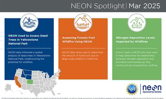
NEON’s Impact on Wildfire Research: Assessing Dead Trees in Yellowstone National Park, Forest Loss in California and Nitrogen Deposition Levels in Colorado
Read More
BATTELLE UPDATES
Receive updates from Battelle for an all-access pass to the incredible work of Battelle researchers.